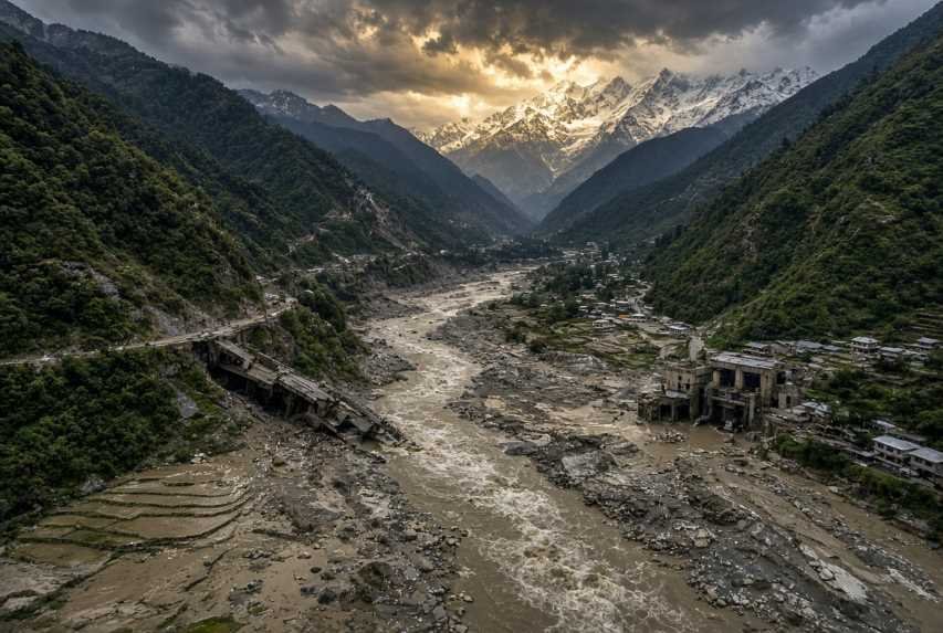
On the morning of 26 August 2026, a high-altitude collapse of rock and glacier ice on the north face of Langtang Lirung sent a torrent of debris into the Lhende Khola, then into the Bhotekoshi and Trishuli river system. Within about 30 minutes, downstream gauges recorded water-level rises of seven to nine meres. Settlements, roads, bridges and hydropower works in northern and central Nepal were torn apart. By 2 September 2026, Nepal’s National Disaster Risk Reduction and Management Authority (NDRRMA) figures cited by international agencies put confirmed deaths above 1,050, with nearly 4,000 people still missing. Chinese authorities reported 16 deaths and more than 500 missing on the Tibet side of the same event.
That disaster is exceptional in scale, but it is not an isolated story. Nepal floods every monsoon. The country’s rivers rise in the Himalaya, race through steep mid-hill gorges, and spread across the Terai plains that feed much of the nation—and, beyond the border, large parts of India and Bangladesh. Floods in Nepal are therefore a Himalayan problem, a South Asian water problem, and a development problem at the same time.
This article explains why Nepal is so exposed, how climate change is changing the risk without being the sole cause of any single flood, what the human and economic costs look like, and how forecasting, sensors, satellite systems and better planning can reduce the next disaster.
Why Nepal Is So Vulnerable
Nepal occupies a narrow strip of land that climbs from the Gangetic plains to some of the highest peaks on Earth. That gradient is the first reason floods here are so violent.
Rain or meltwater that falls high in the mountains does not linger. It concentrates in short, steep catchments and arrives downstream as a sudden pulse. A storm that looks local on a weather map can raise a river ten of kilometers away in a matter of hours. When a landslide, ice-rock avalanche or temporary debris dam fails, the pulse can arrive in minutes.
Three landscapes share the risk in different ways:
High Himalaya: glaciers, snowfields, permafrost slopes, and glacial lakes. Failures here can produce flash floods and debris flows that look more like a moving hillside than a river in flood.
Mid-hills and river gorges: narrow valleys where roads, hydropower plants, markets and district towns sit on river terraces. There is little room to escape sideways.
Terai and inner valleys: flatter land where monsoon rivers overtop banks, drain poorly through towns, and stay on fields for days.
Kathmandu Valley sits in a fourth category: a rapidly urbanizing intermontane basin whose rivers are small by Himalayan standards but whose drainage has been squeezed by construction.
International interest is not only humanitarian. Nepal’s rivers are tributaries of the Ganges system. Damage to hydropower, highways and border crossings affects trade. A flood that starts near the China–Nepal frontier can carry bodies, sediment and contamination into India. And the Himalaya is one of the world’s most closely watched climate frontiers: ice loss here is a signal of what is happening to the so-called Third Pole.
Why Does Nepal Experience Severe Floods?
The monsoon
Most of Nepal’s annual rainfall arrives between June and September. In many basins, the monsoon accounts for roughly three-quarters or more of yearly precipitation. That concentration of water is normal. What is not always normal is the intensity of individual storms, the saturation of slopes before those storms arrive, and the way human settlement has moved into the path of the water.
Extreme rainfall and flash floods
A flash flood is a sudden, fast-rising flood with little warning. In Nepal it is often produced by:
a cloudburst over a small mountain catchment
a landslide that dams a river and then bursts
an ice-rock avalanche or glacial collapse that liquefies into a debris-laden surge
a glacial lake outburst flood (GLOF)
River floods, by contrast, develop more slowly as large rivers such as the Koshi, Gandaki (Narayani) and Karnali fill from many tributaries. They inundate the Terai and can last days. Urban flooding is different again: intense rain falls on paved surfaces, blocked drains and encroached river corridors, so water ponds in streets even when a major river is not in extreme flood.
Himalayan geography and rapid river flow
Steep slopes mean high stream power. Floods here do not only drown; they scour. They move boulders, collapse bridges, undercut roads and bury farmland under sand and gravel. That is why a short event can erase years of infrastructure investment.
Snow, glacier melt and landslides
Meltwater adds to river flow in late spring and early summer and can combine with monsoon rain. Landslides are both a cause and a consequence of flooding. Saturated slopes fail; failed slopes block channels; blocked channels burst. The 2014 Sunkoshi landslide dam and the 2021 Melamchi disaster are examples of this cascade.
Human factors
Natural exposure is made worse by:
Deforestation and slope cutting, which reduce the land’s ability to hold soil and water
Unplanned urbanization, especially in Kathmandu and riverside bazaars
Poor drainage and the conversion of ponds, fields and floodplains into concrete
Construction in flood-prone zones, including hydropower camps, highways and housing on river terraces
River encroachment and extraction of sand and gravel from channels
Climate change sits across these factors. It does not invent Nepal’s monsoon or its mountains. It changes how often extremes occur, how glaciers and frozen slopes behave, and how much water a given storm can deliver.
Nepal’s Major Rivers and Flood Risk
Almost all of Nepal’s large rivers flow south from the Himalaya toward India.
River system | Character | Flood relevance |
|---|---|---|
| Koshi (Sapta Koshi) | Nepal’s largest river system; gathers seven major tributaries in the east | Historic Terai inundation; 2008 embankment breach; transboundary flows into Bihar |
| Gandaki / Narayani | Central Nepal; includes Kali Gandaki, Trishuli, Marshyangdi and others | Steep mid-hill gorges; hydropower concentration; 2026 Trishuli–Bhotekoshi disaster |
| Karnali | Western Nepal’s great river | Remote catchments; 2014 western floods among the costliest in recent records |
| Mahakali | Western border river with India | Floods and bridge losses in the far west |
| Bagmati | Drains Kathmandu Valley then the inner Terai | Urban flooding in the capital; 1993 and 2024 disasters |
The Bhotekoshi–Trishuli corridor, at the center of the August 2026 catastrophe, shows the typical Himalayan pattern. Rain or a slope failure high near the Tibet border is funneled into a single gorge. Towns such as those in Rasuwa and Nuwakot, hydropower tunnels, the Rasuwagadhi crossing and then downstream districts including Dhading, Gorkha, Tanahun, Nawalparasi and Chitwan all sit on the same moving mass of water. That is why so many recovered bodies in 2026 were found far downstream of the original collapse.
Rainfall in the mountains can raise lower-basin levels before local rain has even begun. That is the core forecasting challenge: the water that kills people in the plains or mid-hills may have fallen—or been released—hours earlier and thousands of meters higher.
The Role of Climate Change
The scientifically grounded statement is this: climate change is increasing several of the conditions that make Himalayan floods more likely and more damaging. That is not the same as saying climate change “caused” the flood of 26 August 2026.
What the evidence supports
The Hindu Kush Himalaya is warming, with stronger warming at higher elevations.
Glacier mass loss has accelerated. ICIMOD assessments reported in 2026 that ice-loss rates across the region have roughly doubled since 2000, and that glaciers lost a substantial share of their area between 1990 and 2020.
More precipitation is falling as rain rather than snow at elevations that used to stay colder, which can raise runoff and lake inflows.
Permafrost thaw weakens the ice that acts like cement in high rock faces. Scientists studying the Langtang Lirung collapse have said warming can destabilize such slopes, while also warning that a formal attribution study of this single failure was not yet complete in the first week after the event.
Monsoon extremes are becoming more erratic in many Himalayan analyses: intense bursts, unusual timing, and heavier short-duration rainfall.
Glacial lakes are growing as glaciers retreat, raising GLOF potential.
What remains uncertain
The precise share of climate change in any one monsoon cloudburst.
Whether a particular slope would have failed in a pre-industrial climate.
How quickly GLOF risk will rise in each basin, because lake growth, dam strength and avalanche triggers vary locally.
Future monsoon timing at district scale. Models agree on a warmer Himalaya; they do not give a single, sharp forecast for every valley.
Prime Minister Balendra Shah publicly linked the August 2026 flood to climate change. That political statement reflects a real regional trend. Scientific caution still matters: the trigger was a rock-and-ice avalanche, not a classic lake outburst, and researchers used satellite imagery and seismic records to rule out an earthquake as the cause. The collapse itself registered as a magnitude 5.2 seismic signal on U.S. Geological Survey instruments.
Climate change is best understood as a risk multiplier. Geography supplies the steepness. The monsoon supplies the water. Development puts people and power plants in the channel. Warming makes frozen mountains less stable and extreme rain more likely.
Human Impact
The August 2026 floods showed, in compressed form, every human cost Nepal already knows from ordinary monsoon years.
Lives. Confirmed deaths in Nepal passed 1,050 by 2 September 2026, with figures still changing as search teams reached new debris fields. Nearly 4,000 people were listed as missing, including hundreds of foreign workers and visitors and dozens of security personnel. Chinese authorities reported 16 deaths and hundreds missing in Tibet. Indian agencies recovered bodies from rivers further downstream.
Homes and displacement. Entire riverside settlements were stripped to bedrock. UNDP’s preliminary estimate put debris at about 2.2 to 2.4 million tons—buildings, rock, sediment and household goods. Thousands of people were in displacement sites in Nuwakot and Rasuwa within a week.
Health and identification. Mortuaries filled. Many recovered bodies were unidentified; DNA sampling preceded mass burials. The UN flagged contamination and disease risk in temporary shelters. Only a small share of recovered bodies had been identified in the first days, according to health officials quoted by international media.
Services. Roads and bridges vanished. Power and communications failed across pockets of the mid-hills. At least 19 schools were reported damaged, nine of them destroyed; some intact schools became shelters. UNICEF-linked reporting warned that more than 10,000 school-age children could need psychosocial support and that more than 100 children might have been separated from caregivers.
Work and isolation. Hydropower construction camps became search sites. Rural municipalities lost their offices. Remote mountain communities were cut off because the same gorge that carries the river also carries the only road.
Children, older people, low-income families and isolated households are hit first for simple reasons. They move more slowly. They live in cheaper houses on cheaper land—often closer to the river. They have fewer savings, weaker document trails for aid, and less access to phones, vehicles and official information. Migrant workers in tunnels and riverbed camps face a different vulnerability: they are far from family networks and may not even be on local government lists.
Tourism and pilgrimage add another layer. Foreign nationals among the missing in 2026 included trekkers and travelers using the Rasuwagadhi corridor. When a Himalayan flood closes a border road, it closes a livelihood as well as a rescue route.
Economic Impact
Nepal’s flood bill is not only the cost of one week in August. It is the sum of a monsoon that returns every year and a handful of events that wipe out a visible share of annual output.
What is known from recent assessments
NDRRMA’s preliminary assessment of the September 2024 floods and landslides put total losses at about NPR 46.68 billion. Physical infrastructure accounted for roughly NPR 38.92 billion, including about NPR 27.98 billion for roads. Agriculture and livestock losses were estimated near NPR 5.88 billion, with 65,380 hectares of farmland affected and 26,698 livestock lost. About 249 people were reported dead and 178 injured in that assessment. IMF staff later placed 2024 flood-related damage in the region of 1 percent of the previous year’s GDP when housing estimates were included.
The 2017 Terai floods were worse in relative economic terms. Nepal’s Post Flood Recovery Needs Assessment put damage and losses at about NPR 60.7 billion (around USD 585 million then), or roughly 2 percent of GDP, with recovery needs near NPR 73.2 billion.
Household surveys supported by UNDP Nepal have pointed to farm and off-farm losses running to hundreds of billions of rupees over multi-year periods—an indication that official event tallies miss a great deal of private damage.
Analyses of 2015–2025 weather disasters have found floods among the leading killers and a large share of disaster losses. Average annual disaster loss is modest as a share of GDP in ordinary years, but extreme years can cost many times the average.
The 2026 disaster’s economic outline
A full loss assessment for August 2026 was still underway in early September. Early official remarks should be read as orders of magnitude, not final accounts:
A preliminary government figure reported in contemporary coverage put immediate damages around NPR 200 billion (about USD 1.3 billion).
Finance Minister Swarnim Wagle was reported as saying reconstruction could run to about NPR 762 billion, or USD 4–5 billion—a sum large enough to be several percent of national output.
At least 11 to 13 hydropower projects were described as damaged. Nepal Electricity Authority comments spoke of losses in the hundreds of billions of rupees for generation, transmission and distribution taken together.
Road officials cited initial estimates on the order of NPR 15 billion for roads and bridges in the first days, with dozens of bridges and tens of kilometers of road affected.
International aid pledges exceeded USD 42 million within the first week, according to the prime minister, with more expected.
Those numbers will move. What will not move is the pattern: infrastructure takes the largest official share; agriculture takes the largest livelihood share; hydropower and highways concentrate risk in the same valleys; and reconstruction lasts far longer than the flood.
Business interruption follows the roads. When the Trishuli corridor and a China–Nepal crossing fail, cargo, tourism and construction stop together. Supply chains for food, fuel and building materials stretch. Government spending shifts from development to debris. That is how a mountain flood becomes a multi-year development setback.
Environmental Impact
A Himalayan flood is a geological event as well as a hydrological one.
Erosion and farmland. Floods strip topsoil from slopes and dump coarse sand on paddies. Fields can be unusable for a season or permanently converted to riverbed.
Rivers and sediment. Channels widen, shift and fill. Temporary dams form and fail. Aquatic habitats are scoured. Drinking-water intakes clog or break.
Forests and wildlife. Riparian forest is uprooted. Animals are drowned or displaced. In steep valleys, the floodplain is also the wildlife corridor.
Water quality and waste. Dead livestock, household chemicals, fuel from vehicles and wrecked plants, and human waste enter the flow. Standing water in towns raises disease risk.
Beneficial effects exist, but they are not a consolation. Over long timescales, floods deliver fine sediment that builds floodplain fertility. In the Terai, that process helped create the farmland that now feeds millions. A debris-laden flash flood that buries a town under rock is not that process. The ecological “service” of sediment pulse and the social disaster of a gorge flood are not the same phenomenon.
Nepal’s Government and Emergency Response
Nepal’s modern disaster system was rebuilt after the 2015 earthquake. The Disaster Risk Reduction and Management Act and the creation of NDRRMA moved the country from ad hoc response toward a permanent authority, a national portal (BIPAD), and closer work with the Department of Hydrology and Meteorology (DHM).
In a major flood the response typically includes:
DHM rainfall and river forecasts
NDRRMA coordination and public alerts
Nepal Army, Nepal Police and Armed Police Force search and rescue
local governments opening schools and public buildings as shelters
food, water and medical distribution
later, reconstruction programs through line ministries
The August 2026 operation showed both capacity and limits. More than 20,000 security personnel were deployed. The army flew hundreds of sorties and evacuated thousands of Nepali and foreign nationals. International tunnel-rescue specialists from China, India and other countries joined the search at hydropower sites. More than 11,000 people were reported rescued within a week. Power and communications returned in some areas.
The limits were equally clear. NDRRMA officials told interviewers that people in the path of the surge had little more than minutes of warning. High-mountain weather stations are sparse. Real-time data from the Chinese side of the catchment is not automatic. Helicopters cannot land safely on deep mud. Tunnels filled with sludge are among the hardest rescue environments on earth. Identification of the dead lagged recovery of the dead.
Mountain response is not only a matter of courage. It is a matter of minutes, landing zones, fuel, satellite bandwidth and whether the warning reached a phone that still had a signal.
Technology and Flood Prediction
For a science and technology audience, the useful question is not whether Nepal can stop the monsoon. It is whether an integrated observing system can buy hours—and whether those hours reach the right people.
Tools already in use or available
Satellite monitoring: optical satellites (including Landsat and commercial high-resolution constellations) and radar satellites that see through cloud. UNOSAT has deployed Sentinel-1 AI flood mapping over Nepal. After 26 August 2026, Indian and NASA–USGS imagery helped scientists reconstruct the Langtang Lirung failure within days.
Weather radar and numerical forecasts: DHM and regional centers such as RIMES produce rainfall and streamflow guidance. Coverage is uneven in high terrain.
River-level sensors and automatic weather stations: reporting in recent years has pointed to on the order of 200 hydrological stations and more than 300 automatic weather stations feeding national systems. Many mid-hill and high-altitude tributaries remain thinly instrumented.
BIPAD and DHM portals: national dashboards for incidents, river warning levels and rainfall.
SMS, sirens and mobile alerts: community flood early-warning systems, some dating to work on Tsho Rolpa in the 1990s, now sit alongside mass messaging. Lead times on ordinary river floods can range from under an hour to several hours depending on distance from the upstream gauge.
GIS and digital disaster maps: hazard mapping for floods, landslides and GLOFs.
Drones: used for search, damage sketches and, in 2026, locating bodies in houses that teams could not yet enter safely.
Hydrological models: routing rainfall into river flow; still limited where landslides suddenly change the channel.
IoT sensors: low-cost water-level and rainfall nodes that can densify the network if they are maintained.
AI: flood-extent extraction from radar, damage detection on satellite images, household-level anticipatory platforms such as DASTAA, and even volunteer-built portals that merged official feeds during the 2026 search.
What an integrated system would look like
A practical architecture is not a single app. It is a chain:
Satellites and high-mountain cameras watch glaciers, lakes and steep faces.
Seismic and infrasound sensors flag sudden slope failures the way the Langtang collapse produced a recorded seismic pulse.
Rainfall radar and weather models estimate what will fall in the next 6–24 hours.
River gauges and IoT nodes confirm what is actually rising.
Hydrological and debris-flow models translate those inputs into minutes-to-hours of travel time down each gorge.
AI systems rank which settlements, tunnels, highways and plants sit in the inundation path.
Alerts leave through SMS, cell broadcast, sirens, radio and local government networks—in Nepali and local languages, with instructions, not only color codes.
After the peak, drones and radar maps guide rescue and then reconstruction.
The 2026 flood exposed the missing links in that chain: high-altitude observations, transboundary data, debris-flow models (ordinary river models do not capture a 9-metre rise in 30 minutes), and last-mile delivery when towers fall. Technology cannot move a mountain. It can move a warning faster than the water.
Glacial Lake Outburst Floods
A GLOF is the sudden release of a lake that has formed as a glacier retreats. Meltwater ponds behind a dam of ice, rock and moraine. If that dam is overtopped or weakened by an avalanche, earthquake or internal collapse, the lake can empty in minutes to hours. The flood is typically a mix of water, ice and debris.
ICIMOD and partners inventoried thousands of glacial lakes in the Koshi, Gandaki and Karnali basins. A 2020 assessment identified 47 potentially dangerous glacial lakes in those basins: 21 in Nepal, 25 in Tibet, and one in India. Across the wider Hindu Kush Himalaya, ICIMOD has described on the order of 200 lakes as dangerous. Lakes grow as glaciers shrink. Rank I lakes such as those often cited in Nepal’s risk lists—including names that recur in engineering studies, such as Tsho Rolpa, Imja, Lower Barun and others—have been the focus of lowering, siphoning and siren projects for decades.
Nepal has a documented GLOF history. Events on the Bhote Koshi / Sun Koshi system in 1964 and 1981 and the Dig Tsho outburst in 1985 are standard reference points. In August 2024, a glacial-lake outburst at Thame in Solukhumbu damaged houses, a school and other infrastructure. ICIMOD has also recorded GLOFs that began in China and caused damage in Nepal—eight such transboundary cases appear in regional compilations.
The August 2026 Langtang disaster was not classified as a GLOF by the studies released in the following days. Researchers found no evidence of a lake burst on that alignment. The mechanism was an ice-rock avalanche that entered a river and, in some reconstructions, briefly dammed it before the dam failed. That distinction matters for monitoring. A lake can be watched with water-level sensors. A hanging glacier and a thawing rock face need different instruments: repeat satellite imagery, ground radar, thermal change, and seismic triggers.
Downstream, the difference is smaller. Whether the water comes from a lake or from pulverised ice and a failed slope, a gorge community faces the same wall of debris.
Urban Flooding in Kathmandu and Other Cities
Kathmandu can flood without a Himalayan collapse. The September 2024 rains set 24-hour records at dozens of stations and pushed valley floodwater well beyond normal channel width. People died in the capital region not because the Bagmati is the Koshi, but because the city had covered its sponges.
Drivers of urban flooding include:
rapid expansion onto former fields and riverbanks
loss of ponds, wetlands and agricultural infiltration
concrete and asphalt
drains blocked by waste and sediment
buildings and roads inside the river’s historic corridor
extreme rainfall that exceeds design assumptions
Smart-city responses that fit Nepal’s budget are unglamorous: map every drain; keep it clear; restore river setbacks; require permeable surfaces; use sensors at choke points; tie traffic and school closures to DHM alerts; stop new construction in mapped floodways. Radar nowcasts and street-level inundation models can help, but they fail if the physical drain is full of plastic.
Pokhara, Nepalgunj, Biratnagar and other towns face their own versions of the same problem: monsoon water plus paved growth plus rivers that have been treated as vacant land.
Agriculture and Food Security
Rice is planted and grown through the same months the rivers rise. That is the central food-security dilemma.
Floods destroy standing crops, bury land under sand, drown or wash away livestock, break irrigation canals, and cut the roads that take surplus to market. After the water drops, prices can rise even in undamaged districts because transport has failed. National cereal balance depends on the Terai; a wide Terai flood is a national food event. A mid-hill debris flow is a village food event that statistics may never fully capture.
The 2024 assessment’s 65,380 damaged hectares and nearly 27,000 lost animals are a snapshot of one year, not a full national food account. The 2017 Terai floods affected agriculture on a still larger footprint.
Resilience is a stack of modest measures:
flood-tolerant rice where breeding and seed systems allow
raised grain stores and fodder platforms
insurance that actually pays
irrigation intakes sited and armored for debris
forecasts that reach farmers in time to move animals
land-use rules that stop the most dangerous riverbed farming from becoming permanent settlement
Technology helps most when it is seasonal, not cinematic: a voice alert in the local language three hours before a tributary peak is worth more than a national dashboard the farmer never sees.
Roads, Bridges, and Infrastructure
Nepal’s roads follow rivers because the alternative is a cliff. That single fact explains why floods and landslides close the country.
A gorge road has nowhere to retreat. A bridge is both a crossing and a constriction that collects debris. Hydropower headworks, penstocks and underground powerhouses sit in the same corridors because that is where the drop in elevation—and therefore the energy—is. When the river rises, it takes the economy’s spine with it.
The 2024 monsoon assessment already showed roads as the largest infrastructure loss line. The 2026 event added a harsher lesson: tunnels can become tombs, and a damaged plant is not only a lost megawatt. It is lost export revenue, lost construction wages, and a long outage for towns on the same line.
Resilient infrastructure means:
bridges designed for debris load, not only water load
roads with independent escape alignments where possible
slope stabilization and controlled drainage above highways
hydropower siting that treats GLOF and ice-rock avalanche maps as design inputs, not footnotes
redundant fiber and microwave links so that a fallen tower does not silence a district
airports and helipads kept usable as relief hubs
Rural connectivity is a safety system. A village with no road after a flood is a village that waits.
Regional Impact
Nepal does not own the water that leaves it.
The Koshi, Gandaki and Karnali enter India as major Ganges tributaries. Bangladesh sits still further downstream. A breach on the Koshi has flooded Bihar before. Bodies recovered in India after 26 August 2026 were a grim reminder that a Himalayan surge does not stop at a border pillar.
Cooperation that actually reduces deaths includes:
real-time river and rainfall data shared across China, Nepal and India
joint protocols for high-mountain slope and lake hazards, not only monsoon gauge heights
compatible warning levels so that a “danger” reading means the same thing on both banks
coordinated reservoir and barrage operations where they exist
customs and immigration plans for when a crossing such as Rasuwagadhi or Tatopani is destroyed
Data sharing with China was an explicit gap named by Nepali officials after the 2026 flood. Satellites can see a collapse from space. They cannot replace a rain gauge and a radio link in the catchment next door.
Lessons From Previous Nepal Floods
Figures below use commonly cited official or scientific totals. Sources sometimes disagree; where they do, the table uses ranges or notes.
| Year | Region | Main cause | Deaths (approx.) | Economic damage (as reported) | Major lessons |
|---|---|---|---|---|---|
| 1993 | Central Nepal (Bagmati–Kulekhani) | Extreme monsoon cloudburst; 540 mm in a day at Tistung | About 1,336 nationwide in flood- and landslide-related losses that year | Not standardized in modern GDP terms | Still the modern benchmark for monsoon death toll; storage hydropower and barrages can fail in the same storm |
| 2008 | Eastern Terai (Koshi) | Embankment breach | Deaths concentrated more in India; large displacement in Nepal | Major agricultural and housing losses; exact Nepal-only totals vary by source | Transboundary infrastructure failure can drown the plains without a Himalayan collapse |
| 2014 | Sunkoshi / central-eastern hills; also, costly western flooding | Landslide dam; monsoon floods | Flood deaths that year included a large July–August toll in official monthly data | Among the highest annual flood-loss years of the 2010s | A blocked river is a second disaster waiting to happen; evacuation before a dam burst saves lives |
| 2017 | Terai, 35 districts | Prolonged monsoon inundation | On the order of 130–170 flood deaths in national compilations; 1.7 million people affected | About NPR 60.7 billion damage/loss (~2% of GDP) | Slow-onset plains floods destroy livelihoods even when they kill fewer people than a gorge surge |
| 2021 | Melamchi / Sindhupalchok and other basins | Cascading debris flow: rain, slope failure, sediment | Relatively few confirmed deaths compared with destruction; many missing in the first counts | Tens of billions of rupees; Melamchi water-supply headworks wrecked | Mountain floods are sediment disasters; new infrastructure is not safe simply because it is new |
| 2024 (16 Aug) | Thame, Solukhumbu | GLOF | Low death toll relative to property loss | About NPR 800 million in local reporting | Even a “small” GLOF can erase a village’s buildings |
| 2024 (26–28 Sep) | Kathmandu Valley and multiple basins | Record rains, landslides, urban and river floods | About 249 dead, 178 injured (NDRRMA preliminary) | About NPR 46.68 billion | Cities flood from planning failure as much as from rainfall; roads dominate the loss sheet |
| 2026 (26 Aug) | Rasuwa–Trishuli corridor to Chitwan and beyond; Tibet | Ice-rock avalanche into Lhende–Bhotekoshi–Trishuli | 1,050+ confirmed in Nepal as of 2 Sep 2026; ~4,000 missing; 16 dead in China | Preliminary NPR 200 billion+; reconstruction talk of USD 4–5 billion | Minutes matter; hydropower camps and border towns sit on the same fuse; transboundary mountain monitoring is still too weak |
The lesson that repeats is not mysterious. Nepal does not lack bravery in response. It lacks time, high-altitude observation, enforced setbacks from rivers, and infrastructure designed for debris—not only for water.
What Nepal Can Do to Reduce Future Flood Damage
No single project will make the Himalaya safe. A program can make fewer deaths the normal outcome of a bad monsoon.
Land-use planning that is enforced, not only mapped: no new critical buildings on active flood terraces.
River restoration where channels have been pinched by fill and extraction.
Drainage in cities as serious infrastructure, inspected before every monsoon.
Reforestation and slope management above roads and towns, paired with engineering where trees are not enough.
Flood defenses that match the hazard: embankments on the Terai, debris-compatible bridges in the hills, lake lowering where GLOF models justify it.
Early warning with mountain sensors, seismic triggers, cell broadcast and community sirens.
Climate adaptation that treats permafrost, glaciers and extreme rain as design conditions.
Roads and hydropower rebuilt to a higher standard rather than to the previous footprint.
Insurance and contingent finance so that reconstruction does not wait on an emergency budget fight.
Regional agreements that move rainfall, river and slope data across borders in minutes.
AI and satellites as parts of the official system, not as volunteer add-ons after the fact.
Education that teaches children not to cross a brown river and teaches local governments how to read a forecast.
What Individuals and Communities Can Do
Official systems fail at the last mile more often than they fail at the satellite. Households still have leverage.
Watch DHM and local government warnings during June–September, and after unusual high-mountain reports at any season.
Keep a small kit: water, torch, radio or charged power bank, medicines, dry food, copies of identity papers in a waterproof pouch.
Know the uphill evacuation path, not the road that follows the river.
Never drive or walk a flooded crossing. Most “I can make it” deaths in monsoon countries happen on familiar roads.
Move animals and stored grain if a warning names your river.
Check on children, older neighbors and people living alone.
Treat an evacuation order as a fact, not a negotiation.
After the peak, assume wells and river water are unsafe until told otherwise.
Frequently Asked Questions
- Why does Nepal flood?
Because steep mountains, a concentrated monsoon, unstable slopes and settlements in river valleys coincide. Climate change and poor planning make the same geography more dangerous. - When is Nepal’s flood season?
The core season is the monsoon, June to September. GLOFs, ice-rock avalanches and unseasonal rain can produce floods outside those months. - Which areas are most vulnerable?
High Mountain valleys below glaciers and steep faces; mid-hill gorges with roads and hydropower; the Terai floodplains; and poorly drained cities such as Kathmandu. - How does climate change affect Nepal floods?
It is raising temperatures, shrinking glaciers, thawing permafrost, enlarging many glacial lakes and loading the dice toward more intense rainfall. It is a multiplier, not a substitute for geography and land use. - What is a flash flood?
A flood that rises with little warning, usually from intense rain, a dam or landslide failure, or a sudden mountain collapse. - What is a GLOF?
A glacial lake outburst flood: the sudden emptying of a meltwater lake. The 2026 Langtang disaster was a related but different process—an ice-rock avalanche into a river. - Can AI predict floods?
AI can map water from satellites, estimate which places will flood from a given rainfall, and speed up alerts. It cannot predict a specific slope collapse days in advance with certainty. Combined with sensors and models, it can still save hours. - How can Nepal reduce flood deaths?
Move people out of the most dangerous sites, warn them earlier, and build roads, bridges and power plants that expect debris. The 2026 death toll was a failure of time as much as a failure of rainfall.
Nepal Floods at a Glance
Figures are dated. The August 2026 disaster totals were still being revised as of 2 September 2026.
26 August 2026, ~08:37 local time: ice-rock avalanche from Langtang Lirung into the Lhende Khola; USGS seismic magnitude 5.2 from the collapse itself.
Water rise: 7–9 meters in about 30 minutes on downstream Trishuli gauges (ICIMOD).
Nepal deaths: more than 1,050 confirmed by 2 September 2026 (NDRRMA figures via Reuters and other agencies); some later same-day updates were higher as recovery continued.
Missing in Nepal: about 3,900–4,000, including about 583 foreign nationals in NDRRMA tallies cited on 1–2 September.
China/Tibet: 16 dead, about 546 missing (Chinese official updates through 31 August).
Rescued: more than 11,000 in the first week.
Debris: about 2.2–2.4 million tons (UNDP preliminary).
Hydropower: 11+ projects damaged; hundreds of workers missing from sites and tunnels at the peak of the search.
September 2024 monsoon disaster: ~249 dead; NPR 46.68 billion preliminary loss; 65,380 ha farmland; 26,698 livestock (NDRRMA).
2017 Terai floods: ~NPR 60.7 billion damage and loss; ~2% of GDP; 1.7 million people affected.
1993 monsoon: about 1,336 dead in the year’s flood and landslide disaster accounting; 540 mm daily rain at Tistung.
Glacial lakes: 47 potentially dangerous lakes in the Koshi, Gandaki and Karnali basins (21 in Nepal) per ICIMOD–government inventory work published in 2020; about 200 dangerous lakes across the wider Hindu Kush Himalaya in later ICIMOD communications.
Glacier trend: ice-loss rates in the Hindu Kush Himalaya roughly doubled since 2000 (ICIMOD, 2026 reporting).
Nepal floods because it is built on a staircase of ice, rock and rain. The monsoon will keep coming. Rivers will keep falling from the Himalaya to the Ganges. Climate change is making frozen slopes less trustworthy and extreme downpours more likely. Development has put highways, hydropower and housing on the only flat land a gorge possesses.
The August 2026 disaster was not “just weather.” It was a mountain failure, a warning failure, an infrastructure failure and a regional data failure at once. Future losses will be decided less by whether rain falls than by whether a sensor sees a slope move, whether a message reaches a phone, whether a school stands outside the floodway, and whether three countries treat one river as one system.
Preparedness, technology, planning and climate adaptation will not make Nepal flood-proof. They can make the next surge less fatal than the last. That is the realistic measure of recovery—and the only one that matches the mountains.
 |  |  |
 |  |  |